The City of Philadelphia has launched a network of 76 ground-level air quality sensors across its neighborhoods, providing residents with real-time pollution data through a new public dashboard called Breathe Philly. The initiative, announced on February 18, 2026, by Mayor Cherelle Parker and the Philadelphia Department of Public Health, represents what officials describe as the first deployment of its kind in the United States, with every city address now located within 1.5 miles of a monitoring device.
From Sparse Federal Monitors to Hyperlocal Coverage
Philadelphia previously relied on just 11 federally mandated monitoring stations operated by its Air Management Services division to track pollutants including ozone, carbon monoxide, sulfur dioxide, and particulate matter. While these stations serve regional compliance purposes, environmental health experts have long noted that they fail to capture street-level pollution variations between neighborhoods. Between 2018 and 2024, the city also operated a separate network of 50 ground-level monitors, but that system required manual sample collection and laboratory analysis, meaning data was never available in real time.
The new Breathe Philly network addresses both of these gaps. The 76 sensors track fine particulate matter (PM2.5) and nitrogen dioxide (NO2), pollutants primarily generated by vehicle emissions, industrial activity, and fossil fuel combustion, and transmit hourly readings to a color-coded public dashboard using the U.S. Air Quality Index scale.
Clarity Movement Provides Sensing-as-a-Service Infrastructure
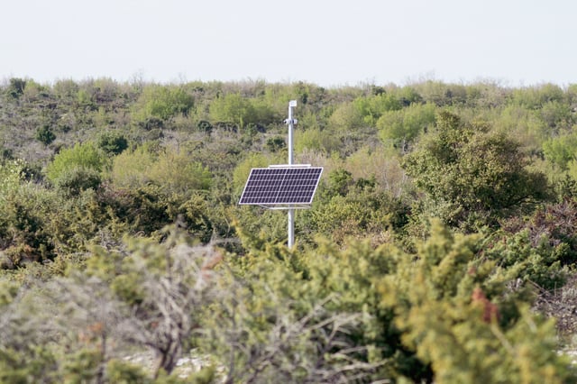
The city’s sensor hardware comes from Clarity Movement Co., a Berkeley, California-based environmental technology company founded in 2014 that operates in more than 85 countries. Philadelphia is procuring the sensors through Clarity’s subscription-based Sensing-as-a-Service model at a cost of $90,000 per year, which covers the solar-powered Node-S devices, cloud-based data management, and ongoing calibration support. The city has not committed to a long-term contract but has indicated plans to maintain the service indefinitely.
The Clarity Node-S units are solar-powered and cellular-connected, eliminating the need for grid electricity or Wi-Fi infrastructure at installation sites. According to Clarity, each device can be installed in under 10 minutes. City Councilmember Nina Ahmad has stated that Philadelphia is the first municipality to deploy the Clarity Node technology at this scale.
Environmental Justice Drives Sensor Placement Strategy
City officials emphasized that sensor placement was deliberate, prioritizing neighborhoods with disproportionate exposure to pollution sources. Philadelphia’s environmental health burden is well documented: the American Lung Association‘s 2025 State of the Air report assigned the city failing grades across all three pollution categories, ozone, short-term particle pollution, and year-round particle levels. The Philadelphia metro area ranked 26th worst in the nation for annual particulate pollution and 43rd worst for ozone, with conditions worsening compared to the prior year’s assessment.
Within the city, pollution exposure is unevenly distributed. Communities along highway corridors and near industrial zones, particularly in North and West Philadelphia, face consistently higher pollution levels. The American Lung Association found that people of color are more than twice as likely as white residents to live in areas with failing air quality grades nationally, a disparity that tracks closely with Philadelphia’s demographics.
Early Detection Already Tested During Industrial Fire
The network’s value was demonstrated almost immediately. When a fire broke out at a waste transfer facility in the Grays Ferry neighborhood in early February 2026, the nearest existing federal monitor, located 1.5 miles away did not detect the smoke. However, a newly installed Breathe Philly sensor at Stinger Square Park, approximately 2,000 feet from the site, registered a shift in air quality from “good” to “moderate.” City officials pointed to this incident as evidence that denser monitoring infrastructure captures localized pollution events that sparse regulatory networks miss.
The event echoed a more serious incident in 2019, when the Philadelphia Energy Solutions refinery in South Philadelphia experienced a fire and series of explosions. At the time, public health officials reported that air quality was safe based on handheld monitors and on-site systems, but dense smoke plumes drifted across South Philadelphia without passing over any of the city’s stationary monitors. Environmental health researchers at the University of Pennsylvania‘s Center of Excellence in Environmental Toxicology have noted that such gaps in coverage undermined public confidence in official air quality assessments.
Data Limitations and What the Sensors Cannot Measure
Despite the expanded coverage, the Breathe Philly network has acknowledged limitations. The Clarity sensors measure only PM2.5 and NO2 and do not track volatile organic compounds, carcinogens, or other hazardous air pollutants that may be released during industrial incidents. Environmental health researchers have also raised concerns about the hourly reporting interval, noting that shorter-duration pollution spikes, lasting minutes rather than hours, could go unrecorded between data transmissions.
These constraints are common across low-cost sensor networks globally. The World Meteorological Organization has noted that while such systems fill critical monitoring gaps, they face challenges around long-term data stability and inter-unit precision compared to regulatory-grade equipment. Philadelphia’s approach, supplementing rather than replacing its existing federal monitoring infrastructure, aligns with best practices recommended by the U.S. Environmental Protection Agency for hybrid monitoring strategies.
Implications for Urban Policy and Smart City Planning
City officials have indicated that data from the Breathe Philly network will inform future policy decisions, though specific measures have not been announced. Potential applications include guiding tree-planting initiatives, shaping transportation and traffic management policies, and informing zoning decisions around industrial development. The real-time dataset also creates opportunities for longitudinal analysis of neighborhood-level air quality trends, which could support evidence-based interventions targeting pollution hotspots.
Philadelphia’s deployment joins a growing wave of municipal air quality sensor investments across major U.S. cities. Chicago announced plans in 2025 to install nearly 280 Clarity sensors, what would be the largest such network in the country, with a particular focus on environmental justice communities on the city’s South and West sides. The trend reflects a broader recognition among municipal governments that traditional regulatory monitoring infrastructure, while essential for federal compliance, provides insufficient granularity for public health decision-making and equitable policy development.