← Back to all events


Intertraffic 2026
Intertraffic Amsterdam is the world’s leading trade event for traffic technology and smart mobility, where companies, cities, and experts showcase innovations in traffic management, road safety, infrastructure, parking, and urban mobility.
High-resolution, Predictive Weather Data: The Next Step for Mobility
📖 Read Video Transcript
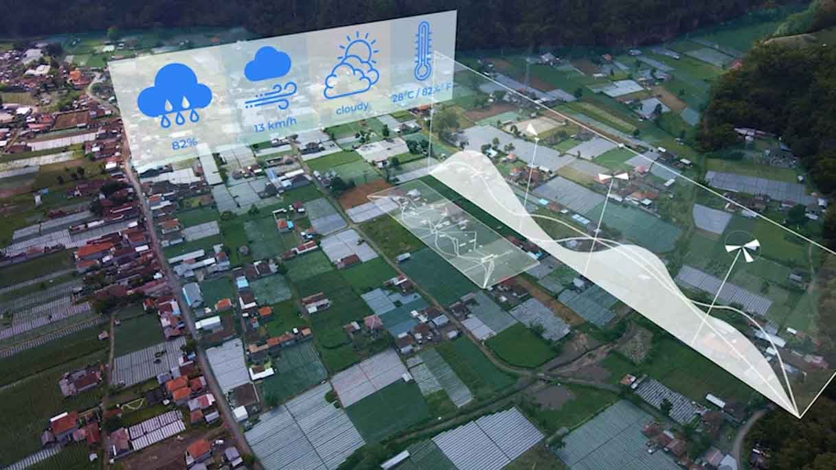
Satellites, weather sensors and stations, radar data, national weather services… There are many ways of gathering weather data, data that is already being used across many sectors but that in traffic and mobility could play a much bigger role. In these times of growing urbanization and increasing climate-related events, just this week, the UN has warned once again of the imbalance of climate, This type of data has become critical. It can add an extra layer of intelligence to traffic systems, helping reduce incidents, avoid congestion, and improve maintenance operations. We deal in principle with high resolution data, high resolution extreme weather data in urban areas, related to flooding events, heat events, storm events, and use this kind of data and combine it with street information, traffic information, road information and produce like a real time and forecast insight. That was Nico Bader, from Meteoblue, a Swiss weather intelligence company that provides global forecasts and climate data using multiple models and AI-driven analytics. The company relies on 250,000 weather stations around the world and other inputs to generate highly localized insights. Weather data is already integrated into traffic systems today, for example, to trigger warnings on variable message signs, adjust speed limits, manage road closures, or support maintenance decisions like salting icy roads. However, most operators or cities are falling short. This information is still used to react and still isn't fully integrated into planning ahead. Of course, so they use it for different kind of management systems already. The thing what they are using currently is very coarse weather data. So on a kilometer scale. But what is interesting for traffic management, especially in urban areas or along highways, is the high resolution data so that you know what's happening within the city, along the street, between the buildings, so that you know what's happening in real time and, that you can provide a prediction within a very, small spatial distance. And then they can decide already now what to do in two hours. So where should we close streets? Granular, predictive data can allow road users, as well as operators and municipalities, to plan ahead and know when they can use certain roads, and when not to use them in advance. Data silos, legacy systems not designed for predictive modelling, and a traditionally reactive mindset are still limiting the full use of this data’s capabilities. And the consequences of this gap are not theoretical. Tragedies like the 2024 Valencia floods showed how quickly extreme weather can turn into a traffic and safety crisis, highlighting the need for better anticipation and response. So historic data helps you to train models for the future and correlate it with historic weather data, historic climate data and see, okay, what type of extreme weather causes different traffic jams or traffic incidents. So we are also using more and more AI, especially not using AI to predict the weather itself, but providing or gathering different types of data, combine them with AI with our weather forecast and use the different type of data to increase the performance and accuracy of our weather data. So especially in the so-called post-processing of weather data, AI becomes more and more interesting. Also for us. With the help of historical data, weather models and AI, systems can now begin to understand patterns, linking specific weather conditions to traffic disruptions and incidents. And while AI is not necessarily used to predict the weather itself, it plays a growing role in improving the accuracy of forecasts and combining multiple data sources into more reliable insights. High-resolution data integrated into traffic systems doesn’t just improve forecasting, but also, decision making. It can reduce congestion, accidents and tragedies. The ROI is clear: saving lives, more accurate traffic management and a smarter infrastructure planning that can survive longer. And while traffic is one of the verticals where this impact is becoming visible, the potential goes far beyond mobility: from energy to urban planning, weather intelligence is becoming a critical layer across multiple industries with startups thriving in this space.
Playlist: Intertraffic 2026
3 videos
Intertraffic 2026: Key Insights from the Event Floor
The State of the Smart Traffic Industry in 2026
High-resolution, Predictive Weather Data: The Next Step for Mobility
🎥 Recent Event Coverage


🎬 Kurrant Originals


© Kurrant. All Rights Reserved.