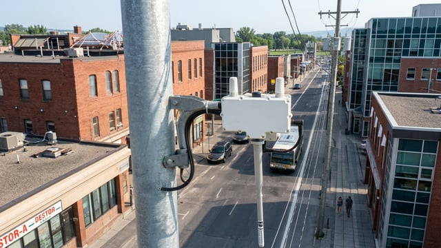
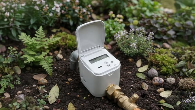
Floodings are becoming more and more common. It's mainly due to climate change, but the changes humans have made to the ecosystem don't help either. As cities grow, more green spaces are destroyed and more forested areas are cut down. So land that usually absorbs water is turned into concrete. There are two options when rain falls, it either runs into a river or the drains, either way, many times, it's more water than they can handle. And if we add that to the fact that climate change brings heavy rain in short times... In the UK, it's been one storm after another in 2023 and there have been many floods in recent years. So the topic is a hot one. We've seen utilities investing heavily in flood sensors like Anglian Water, which rolled out 11,000 sewer monitors. But councils are looking to do their part too, like that of London's Redbridge Borough, which saw the July 2021 floods as a wake up call. We had some areas of the community that was almost three and a half meters underwater. So what we wanted to do is use the data that we had from July 2021, when London had a lot of flash flooding and create those flooding hotspots, which other boroughs have done, too. But what we wanted to do was with those flooding hotspots, look at the particular areas of particular streets and those gullies that were taking the most amount of water into the sewer system to make sure that those were clear. The council used that data to embark, in 2022, on a project to monitor gullies. They purchased 99 drain sensors and put them in drains that, according to data, had been problematic in the past. The goal of the project? Identify when the level of water or build up in the gullies, which are owned by the council, exceeded an established threshold to make sure they weren't blocked and would work properly during extreme weather events, as well as ensure efficient maintenance. It will be able to detect sort of silt and debris within it because it will know that it's of a different consistency. Primarily it will detect water because if you've got a fundamental blockage, the water will be the first thing that the sensor will pick up because the water will build up and it will start to rise up in the gully and it will be able to tell you the water level is at this percentage. So if you think about a gully being blocked the silt will be usually at the bottom. It will then cover the outlet that then allows the water into the sewer system. So what the sensor is reading is the water level rising and then that will give you an indication that there's something blocking. Our objective as a council is to make sure that the gully is clear and that it flows into the sewer system, which is owned and maintained by the relevant utility company. Redbridge Borough went for infrared sensors from company Map16. They purchased the sensors, which are battery operated, and pay a subscription for their Smart City Platform, which informs of levels and has a map-centric interface. Although the pricing wasn't disclosed, we know that sensors tend to cost between 200 and €500 each. To send the data to the platform, they're using LTE connectivity. So this can be changed, varying on our requirements. The standard set up is to sample that data every 15 minutes and send it back to the main dashboard every 3 hours. If the sensor reads that the alert levels have been hit, it will send out any of those 15 minute sample intervals back to the system, and that will allow flood incidents to be detected easily and allow us to make sure that we're getting those alerts on time. The alert comes through the platform in the form of a text message or email, and then staff will go to the gully in question and inspect the issue. If it's a drain problem, they'll fix it. If it's sewer related, they'll notify the utility. One thing is clear, though. There will be a need for a strong collaboration between councils and utilities as their infrastructures are connected, meaning in the future there will be a need for data sharing, something we explored in a previous video. The borough also installed in 2023 three river sensors in the Seven Kings River to measure the level of water and send alerts when the established threshold is surpassed so that the council can take action. The river sensors use the same technology as the drain ones. So far, the solution has allowed for a more efficient gully maintenance. I mean, we’ve definitely seen some positive results because we're no longer having to send out individual people to go and inspect all of the gullies in our flooding hotspots. So there's definitely some efficiencies that we've made there using this technology. From areas that we thought were particularly prone to gullies being blocked, we've been able to demonstrate during severe weather events and heavy rainfall that actually the gullies are performing really, really well. So we don't need to go and clean the gullies as we used to every time before a severe weather event, because we can demonstrate that the gullies are clear. We've been able to use that data to really determine our severe weather response. What we're now looking to do is move some of the gully sensors to other areas in the borough that are reporting blocked gullies. So then we can use that data and see maybe we don't need to clear this particular gully once a year as per our standard procedure. So we're bringing that balance back into the program again and using data-driven analysis to drive our program forward. We ended 2023 discussing how flood monitoring had been and would continue to be a hot topic as more and more municipalities find themselves in need of the solution. Until now, we've seen some projects like New York's FloodNet, which has sensors in hotspots informing of the water level in the streets. However, projects like the one in Redbridge Borough, even though smaller than those led by utilities, prove that municipalities are taking a more proactive approach as they are looking for solutions that will alert them of a situation before it becomes a problem. Dhiresh told me that the council's Highways and Transportation Department is now also looking for a smart solution regarding traffic count that uses already existing data from the commercial world so they can skip installations at the beginning and have a picture of where to focus.
How a London Borough is Using IoT to Curb Urban Flooding
Floodings are becoming more and more common. It's mainly due to climate change, but the changes humans have made to the ecosystem, like replacing forested areas with concrete, don't help either. Drains and sewers aren't able to take in the amount of rainfall that has now become standard with extreme weather events, leaving, on those occasions, streets filled with water. We've seen utilities investing heavily in flood monitoring solutions, but municipalities and councils are also doing their part. The London borough of Redbridge deployed in 2022 and 2023 99 drain sensors and 3 river ones to prevent floodings thanks to efficient gully maintenance.
In this video we interview Dhiresh Bhatt, Head of Highways & Transportation at Redbridge Council, to learn about their drain sensor project and what other solution the department is looking for to improve services.
View transcript auto-generated


Similar Picks


📰 Latest News


🎬 Kurrant Originals


🎥 Recent Event Coverage


Featured Case Studies
Real client work behind the news. Strategy, M&A and engineering projects we've delivered for cities and utilities.


Stay in the Loop
Get smart cities and utilities insights delivered your way. Choose your channel
Join our WhatsApp Channel