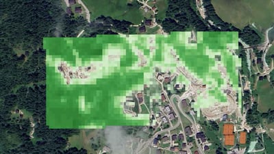
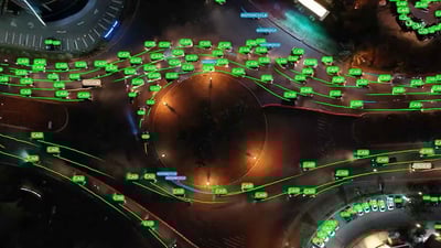
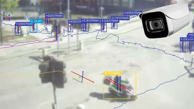
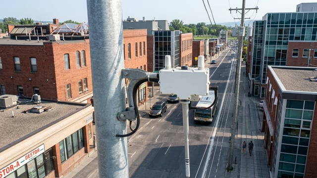
2025 kicked off for Los Angeles residents with devastating fires that burned some 40,000 acres and killed 29 people. After these fires, and as wildfires become more common around to the world, prevention, detection and post-fire recovery technology is back on everyone's radar. California is very familiar with these types of solutions. The state's Department of Forestry and Fire Protection, or CAL FIRE, has actively been using early fire detection technology for over a decade and even created Alert California, a program that uses AI enabled cameras to spot, track and monitor smoke and fire that has played an important role in the state's latest fires. In 2019, we had, through legislation, some funding that would allow us to add some additional ground mounted camera systems to the existing network that Alert California had. UCSD and Alert California had enough data to then build a machine learning model for change detection, and that change detection was for smoke and fire, which then turned into artificial intelligence within the camera system within the network. The program, based at the University of California San Diego and developed with CAL FIRE, utilities and DigitalPath, has led to the deployment of more than 1100 cameras across the Golden State. The devices can allegedly spot smoke and fire up to 60 miles away during the day, and 120 at night. When a camera detects what the AI identifies as smoke or fire, it sends an alert and footage to a control center that verifies, validates, and notifies the emergency command centers of CAL FIRE, allowing those in charge to address the issue. Alerts are sent via text message, email, and a phone call. The program has had a funding of over $20 million. Our mission is to suppress 95% of our fires at ten acres or less. So what we have seen, the success rate with these cameras and what it has done is it's really helped us with that mission of more than 95% of our fires at ten acres or less. So the value and the success that we have seen are the fires that the AI detection has notified us, sent that notification, the command center receives it, dispatches resources to respond. They suppress the fire and then go back without even a 911 phone call, an emergency phone call going into those command centers. The cameras generally use cellular or Wi-Fi connectivity, but can also rely on satellites in off grid areas. They can be powered by solar, batteries or be mounted on utility infrastructure, as these companies are partners and sponsor devices. But the cameras and Alert California aren't the only technology and programs CAL FIRE is relying on to put out fires. Technology plays a role before, during and after fires, something we saw during the recent LA fires. Some of the pre is our predictive services. And a lot of our predictive services products are generated from a company called Technosylva. So they have a wildfire analyst that we have an enterprise license through and that gives us fire risk several days out that we can identify potential heightened hazard within specific areas throughout the state, as well as our fire simulation. So our fire spread simulation. So before the fire happens, we can see that risk. Once the fire does occur and in combination with some of our National Guard assets for early detection, ongoing assessment with the camera detections, we coalesce all of those things to make fire spread predictions. And those will then show us, in a simulated fashion, up to 100 hours of what the possible spread or potential spread of that fire would be. So it gives us a good basis and understanding. If the fire starts here, this is potentially what it could impact. The GIS, AI enabled software prediction system by Technosylva allows the firefighters to identify risk areas. The platform runs simulations thanks to camera, weather, vegetation and soil moisture, topographical, historical, infrastructure, and Earth observation data. After running the simulations, firefighters can see if the area they're working in is a high spread zone, the infrastructures or properties that will be affected to decide where priorities will lie. After all the data is analyzed on the Technosylva software in their common operational platform, they can also see information on jurisdictions, population, waterways, utility infrastructure... All the technologies used are pieces of a puzzle that, put together, allow for a better understanding of the situation on the ground. I think that what we have done, interwoven all of these pieces of technology, whether it's fire guard for the early detection, ongoing assessment or incident awareness and assessment, our fixed wing platforms, our aircraft that are pulling that infrared perimeters, in near to real time. The cameras looking at where that column of smoke is laying over, what is it impacting, the fire spread simulations. Adding all of those things into our Fire Management Assistance Grant, so our FMAG, which then opens the door for additional funding to ensure that those communities are resilient. Drones were also used during the LA fires, but sometimes struggled due to the heavy Santa Ana winds. After the fire, there are still threats that CAL FIRE are assessing with technology. The post-fire threats are mudflows, debris flows, floodings... CAL FIRE is relying on catastrophe risk modeling software Katrisk for flood monitoring to ensure those affected are safe from the aftermath. California has 163,696mi², or 423,970km². It's impossible to cover every inch of the state with cameras to monitor fires. The system allows CAL FIRE to contain fires and keep them from spreading, but when early detection fails due to absence of cameras in an area or due to a rapid spread because of drought or strong winds, it's key for them to have situational awareness, which is made possible thanks to AI driven software models they run. And the LA fires will only reinforce this concept of using AI driven solutions to help fight the great threat wildfires pose, especially in the US' most populous and most fire prone state.
How AI-Enabled Cameras and Predictive Analytics Helped Fight LA Fires
After the recent LA fires, prevention, detection, and post-fire recovery technology is back on everyone’s radar. California’s Department of Forestry and Fire Protection, or CAL FIRE, has actively been using predictive analytics and early fire detection technology for over a decade and created Alert California, a program that uses AI-enabled cameras to spot, track and monitor smoke and fire, that has played an important role in the state’s latest fires.
In this video, we interview Phillip SeLegue, Staff Chief Fire Intelligence for Calfire, to discuss Alert California, and the AI-enabled technology firefighters rely on before, during and after fires.
View transcript auto-generated


📰 Latest News


🎬 Kurrant Originals


🎥 Recent Event Coverage


Featured Case Studies
Real client work behind the news. Strategy, M&A and engineering projects we've delivered for cities and utilities.


Stay in the Loop
Get smart cities and utilities insights delivered your way. Choose your channel
Join our WhatsApp Channel