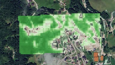
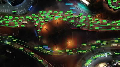
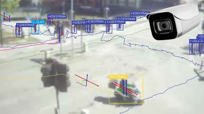
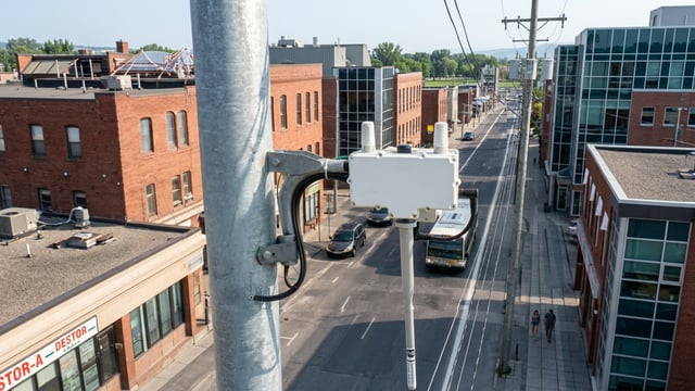
Leonardo da Vinci was among the first people to explore and recognize the potential of viewing a city from above with his aerial perspective maps. Fast forward some 500 years, and humanity has taken it to the next level with satellite Earth exploration. The smart city industry hasn't been left behind and has opened its doors very widely to space. We've been seeing solutions relying on satellites: from Anglian Water, using these spacecrafts to detect leaks in rural main pipes, to start up Meersens using satellite data for environmental monitoring. Earth observation is quickly becoming key in the smart city industry. Satellites can indeed make a difference, so they can provide a huge amount of data and data from satellite to Earth observation sensors is very rich and could be of different nature. Could be of different spatial resolution, ranging from meters to centimeters accuracy. And this is complementing very well sensor data that covers data at local scale with data at global scale. They can also be of different nature: high resolution, hyperspectral imagery or thermal imagery. So therefore they enable a different range of applications to address city needs. And of course it is not only satellite Earth observation, because satellites can also provide satellite connectivity that complements, terrestrial networks. The use of satellites for GPS and communications is nothing new, they've been used since the last century. But what is now making these spacecrafts become the stars is the possibility of applications. They’re used for mobility, infrastructure monitoring, ecosystem modeling, energy planning, different types of leak detection, air quality monitoring... There are endless use cases. But let's focus on air quality monitoring to understand this data’s potential. For this purpose, you can rely on sensors, but it's unsustainable to put one on each street. You can deploy them in specific places, like around schools or hospitals, or on a road to understand if a traffic measure is working. You can integrate sensor data and satellite data for this. Sensors will bring hyperlocal data, and satellites will provide more macro data with sufficient accuracy on the state of air quality in a wider area. It's about the utilization of Sentinel data integrated with other local data and appropriately, processed in order to derive pollen prediction. We had a very successful project in the UK that is now operational in Leicester and piloted in London and in Dubai as well that uses air quality data together with weather data in order to achieve a dynamic, traffic management, in this city. The European Union has the Copernicus programme, operated by the European Space Agency and gives free access to data from the Sentinel satellites in the Copernicus Data Space Ecosystem. The data ranges from air quality and UV radiation to land use or wildfire monitoring. The same type of data is also gathered by NASA satellites and is displayed for free on that Earth data page, for example. The space agencies even provide free APIs to integrate with solutions. In NASA's case, according to their API policies, the APIs are free. Users do have to create a key if they'll be putting in more than 50 daily requests, and with their key, they can make 1000 hourly requests, after which they're blocked from more calls until the hour has passed, or they'll have to contact NASA directly to reach an agreement. This type of data allows smart city vendors and actors to have data very quickly. So rather than just deploying sensors and waiting for the data to come in, they can access this information in minutes at both global and local scales and pair it with what they've already deployed. Typically, the services that really address the core challenges of the the city stakeholders are built on a fusion of data, sensor data and space data, and it's clear that the space data, as they have a global coverage, will be optimal and cost efficient in the sense indeed that they will avoid for the same quality of service, deploying a large amount of sensors throughout all the areas that need to be monitored. Although use cases are endless, satellites can be the star of the show in climate issues. Many efforts are focused on this. For example, QuantCube and the French space agency CNES have created a flood risk digital twin thanks to satellite, ground sensor, and drone data. With the recent flooding in Valencia, Spain, the ESA satellites were used to view the damage and could also be used for future urban planning to better comprehend the scale of floods when rebuilding. Artificial intelligence is bound to make the use of satellite data even easier and more insightful for weather prediction. We've seen this with the partnership between NASA, IBM, and the Oak Ridge National Laboratory. With 40 years worth of climate data, they developed an open access AI model for weather research set to help predict weather patterns and improve resolution. You train a foundation model, so essentially you think about you go from data and now you have a representation of the data in terms of an AI foundation model. The next step is to take the foundation model and train it for specific applications. Now these foundation models can be trained with local data. That's what we call a downscaling process. Previously it can be done very empirical, statistical methods or, what we call dynamic downscaling, meaning having to run forward simulation models, which are also computationally expensive. And it takes time. And now these foundation models can be adapted for specific tasks, in particular regions. And it would be very expensive if you had to start with just modeling and simulation based on fundamental physics, but it'll be computationally very resource intensive. And it would also take a long time. Now the AI models offer the potential for being able to do it cheaper and faster again. They've created a foundation model that can be adapted to specific tasks in specific regions. It's like a one size fits all AI model, and then each city, town, region, or country can fine tune it for their goal. The AI model has been published on The Hugging Face as well as IBM's Granite. Companies in the industry are using satellite data as a differentiator. They can turn to private satellite data companies like Planet Labs, Maxar Technologies or Spire Global, or rely on free satellite data from ESA or NASA. Either way, developers can add an extra layer of insights to their solutions. With all the possibilities and so much data being gathered, we're bound to see more smart city companies looking to space to enable or better their solutions.
Smart City Insights Skyrocket with Satellites
The smart city industry has opened its doors, very widely, to space, with more and more solutions relying on satellite data. From Anglian Water using these spacecrafts to detect leaks in rural main pipes, to startup Meersens using satellite data for environmental monitoring. The applications are endless, and smart city and utility players know it.
In this video we interview Rita Rinaldo, Head of the Projects and Studies Implementation Division at the European Space Agency (ESA), and Valentine Anantharaj, Computational Climate Scientist at the Oak Ridge National Laboratory, to discuss the role of satellite data in the smart city industry, and how AI can skyrocket the use of this data.
View transcript auto-generated


📰 Latest News


🎬 Kurrant Originals


🎥 Recent Event Coverage


Featured Case Studies
Real client work behind the news. Strategy, M&A and engineering projects we've delivered for cities and utilities.
Stay in the Loop
Get smart cities and utilities insights delivered your way. Choose your channel
Join our WhatsApp Channel