The Philadelphia Office of Emergency Management launched a real-time flood monitoring system in the city’s Eastwick neighbourhood on 10 May 2026, installing flood gauges and cameras along flood-prone Cobbs Creek to give residents advance warning before water levels become dangerous. The pilot, which began development in 2024, marks the second phase of a broader citywide flood technology programme that city officials say will expand to additional neighbourhoods as the dataset matures.
Six Cameras, Three Gauges and a Decade of Community Pressure
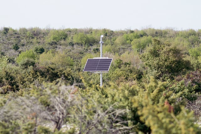
The current installation comprises six cameras and three flood gauges. Each gauge captures water levels, barometric pressure, rainfall, and temperature in real time, feeding data to the city’s emergency management operations centre and, through a forthcoming public dashboard, directly to residents via their phones and computers.
The launch follows more than five years of community advocacy that began in earnest after Tropical Storm Isaias struck in August 2020, flooding approximately 300 homes and prompting around 100 water rescues. Brenda Whitfield, a block captain and representative of the Eastwick United Community Development Corporation, described the moment as a turning point: “That first flooding was just devastating to the community,” she said at the ribbon-cutting event, as quoted by ABC affiliate 6abc. The new equipment, she added, gives neighbours a practical tool that earlier storms made painfully clear was missing: “Now we have something to warn us, to make sure that we get our cars, get our handicapped people, our pets, and make sure we get our things out of the basement and move up to a higher level.”
From Alerts to Live Data
The sensor network builds on ReadyPhiladelphia Eastwick Alerts, the city’s first neighbourhood-targeted emergency messaging service, which launched in 2024 and notifies opted-in residents about incoming storms, flood risk levels, and recovery resources. The new gauges add a granular, instrument-level layer on top of that messaging infrastructure.
Once the public dashboard goes live later in 2026, residents will be able to zoom in to specific blocks, view live gauge readings alongside camera feeds of Cobbs Creek, and decide in real time whether to move a vehicle to higher ground or prepare property for rising water. City officials described the intent at the launch event as delivering actionable information at the block level, not just broad weather warnings.
Multi-Agency Architecture and Federal Backing
The project sits within a layered funding and collaboration structure. FEMA provided a grant of more than $2 million to support interim flood barrier construction in Eastwick using HESCO barriers, temporary metal-framed containers filled with soil, as a stop-gap while longer-term engineered solutions are evaluated. A separate $450,000 FEMA Flood Mitigation Assistance grant funded the development of the city’s Eastwick Flood Resilience Strategy, which calls for combining structural barriers, wetland restoration, upgraded stormwater infrastructure, and voluntary property buyouts.
The monitoring layer itself complements infrastructure work being assessed by the U.S. Army Corps of Engineers, which has been evaluating a scaled-down levee alternative after shelving an earlier, larger barrier design. The U.S. Geological Survey has also contributed to the broader sensor ecosystem.
NOAA projections referenced during the launch period indicate the Mid-Atlantic could experience nine to fourteen high-tide flooding days in 2026, roughly three times the frequency recorded in 2000, underscoring the urgency behind permanent monitoring infrastructure.
A Resident-Driven Model With Broader Ambitions
Eastwick was selected as the pilot site both because of its physical vulnerability and because of sustained community engagement that helped shape the project’s design. The city’s stated intent is to use the pilot to calibrate how to manage and interpret a live sensor network before scaling it to other flood-prone areas.
The Eastwick rollout reflects a pattern gaining traction in U.S. cities, where sensor-based early warning systems are being paired with community notification platforms rather than left as back-office operational tools. Kurrant previously reported on Chicago’s deployment of 50 solar-powered, 5G-connected floodwater sensors developed by startup Hyfi and backed by Verizon, a project that generates live flood maps and can issue alerts up to an hour before inundation begins. Philadelphia’s approach is more municipal in character, integrating city emergency management, federal geological survey data, and a resident-facing dashboard rather than relying on a single commercial IoT platform.
Technical and Funding Gaps Still to Close
Several elements of the programme remain incomplete. The public dashboard had not yet launched as of the sensor unveiling, with its public release projected for later in 2026 according to the city’s Office of Emergency Management annual report. Additional gauge and camera installations across the city are also planned but not yet scheduled. No vendor responsible for the hardware or data platform was publicly named at the launch event; this detail has not been confirmed by official sources.
Funding disruption also affected the timeline. The project, which began in 2024 and took approximately two years to reach the current phase, was partly delayed by the removal of federal flooding protection grants under the Trump administration, according to The Philadelphia Inquirer. How that affects the pace of citywide expansion is not yet clear.