How AI-Powered Satellite Data, Can Increase Sustainability at Major Events like Olympics
View transcript auto-generated
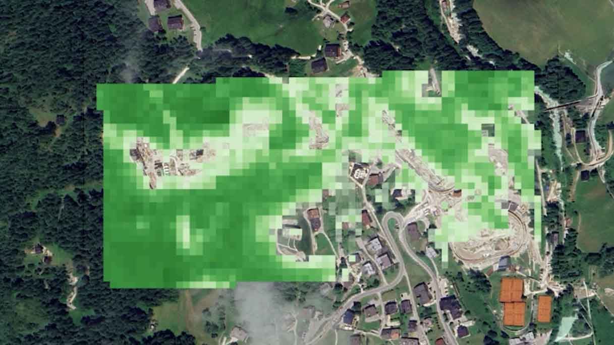
The Canadian finger, the racing wolfdog, the relationship confessions… The Milano-Cortina 2026 Winter Olympics have left us memorable moments, and, according to the International Olympic Committee, also a sustainability legacy. Like Paris before it, Italy promised Games focused on sustainability and infrastructure longevity, upgrading existing venues, modernizing infrastructure, and reducing environmental impact. However, new infrastructure still had to be built, which led to skepticism from environmentalists about the sustainability claims. To build a €118 million 1,749-metre-long steel-and-concrete sliding track in Cortina d’Ampezzo, part of the Ronco Forest in the Dolomites was cleared. Between 500 and 600 larch trees, some over a century old, were cut down. Around seven hectares of forest disappeared to make way for the venue. So, what was the environmental impact of this? That’s where satellite data comes in. An independent study by Italian AI geospatial analytics startup Latitudo 40, which uses satellite remote sensing, Earth observation data and machine learning to gather climate, environmental and urban resilience insights, compared satellite imagery from 2022, when the forest was intact, and 2025, after it had been cleared, to measure this venue’s environmental impact. We took advantage of Latitudo 40 algorithms, and therefore artificial intelligence, to have screenshots of what some indicators were before the event and then after the event. Then we could see indeed the changes. After that, we ran some analysis, statistical analysis and then the data were showing up. The data shows a change in the ground surface, from dense tree canopy to sealed surface. It also shows tree cover density dropped. But the most significant impact was temperature. Where the forest once stood, average surface temperatures increased by around four degrees Celsius. Trees help regulate heat. Without them, the ground absorbs and retains more warmth, leading to what is known as the urban heat island effect. Carbon storage also declined. The analysis found an average loss of 0.54 megagrams, or 540 kilograms, of carbon sequestration capacity, a 30% reduction in the area studied. The goal of the study was to have actual data on the environmental impact of the construction of infrastructure for the Winter Olympics, but also to show how these digital solutions can help before these major events take place. Specifically, for Latitudo 40, we do have technologies nowadays that can help you even predict the future. There are some generative AI and more that can help you know in advance what the impact of your intervention is going to be. So that may be a good way to plan for these types of activities. You can simulate the variables. You can make different master plans to evaluate what's going to be best. For decades, infrastructure planning relied largely on historical data and simplified modelling. While useful, these approaches often struggle to capture increasingly complex and uncertain conditions. Today, AI-driven simulations allow planners to test multiple forward-looking scenarios, stress-test infrastructure under different assumptions, and assess environmental impacts before construction begins. Platforms combining satellite data with predictive modelling, such as those developed by companies like Latitudo 40, aim to support more informed infrastructure decisions. Sustainability controversies are nothing new in these major events. So really, the question is: can these major events truly be sustainable? Probably not, but satellite data and AI could help organizers achieve the highest level of sustainability, comparing alternatives and planning infrastructure using real environmental data. Also allowing citizens to hold event organizers accountable.


📰 Latest News

🎬 Kurrant Originals


🎥 Recent Event Coverage


🎯 Featured Case Studies
Real client work behind the news — strategy, M&A and engineering projects we've delivered for cities and utilities.


Stay in the Loop
Get smart cities and utilities insights delivered your way. Choose your channel
Join our WhatsApp Channel