The MKE FreshAir Collective, a Milwaukee nonprofit that monitors neighborhood air quality, is installing four solar-powered air sensors along the city’s Beerline Trail through September 2026, funded by a $15,000 share of a $100,000 Daybreak Fund grant awarded to Riverworks Development Corp. The deployment extends a citizen-science network that already spans more than two dozen sensors across Milwaukee’s North Side, concentrated in former industrial corridors and neighborhoods with elevated childhood asthma rates.
A $15,000 Sensor Line Item Inside a Green Infrastructure Grant
The funding traces back to the Daybreak Fund, which awarded nearly $1.8 million in 2025 for nature-based climate and water projects across the western Lake Michigan region. Riverworks Development Corp. received support to green the gateway of B-Line Park on the Beerline Trail with bioswales, rain gardens, native plantings and trees, and it carved out $15,000 of that award for air monitoring and community education.
Riverworks maintains the northern portion of the Beerline and serves the Harambee and Riverwest neighborhoods, which gives it a direct stake in local environmental data. “It made a lot of sense for us to support it, because why wouldn’t we want to know about air quality in our neighborhoods?” said Ruth Weill, community development manager at Riverworks Development Corp., in an interview with the Milwaukee Neighborhood News Service.
Solar-Powered IQAir Units Reporting on the 0-to-500 AQI Scale
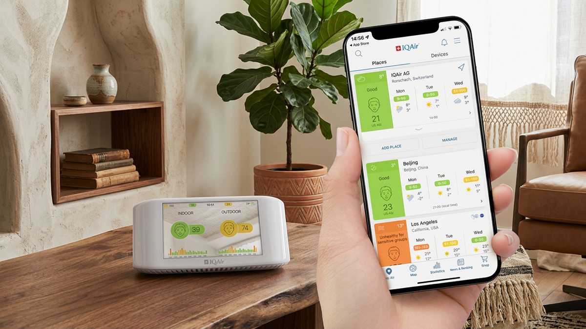
Each sensor measures multiple sizes of particulate matter and carbon dioxide, converting the concentrations into a single value on the U.S. Air Quality Index scale, which runs from 0 to 500, with lower numbers indicating cleaner air. Residents can pull the readings in real time before heading outdoors through the AirVisual app operated by IQAir, the company that supplied the collective with its first sensors in 2019 and has since donated roughly $30,000 in consumer-grade hardware.
Across the wider network, the devices track fine particulate matter at PM1, PM2.5 and PM10, along with other pollutants, and log data hourly. The nonprofit Data You Can Use analyzes those readings into daily and monthly averages so the information is easier for residents and policymakers to interpret.
Siting Sensors Along a Former Beer-Era Rail Line Without Clustering
The Beerline Trail sits partly on an old rail corridor that once served Milwaukee’s brewing industry and now carries pedestrians and cyclists through an industrial stretch. The trail runs southeast from Capitol Drive and Third Street, crosses into Gordon Park at Locust Street, and follows the Milwaukee River toward Kilbourn Reservoir Park and Kadish Park.
A key operational challenge is spacing the four devices far enough apart to capture distinct microclimates rather than duplicating readings. Founder and co-executive director Langston Verdin has said the collective is leaning on residents to flag pollution sources such as truck traffic and exhaust, local knowledge that outside operators rarely hold.
The footprint is also set to grow. The City of Milwaukee and Milwaukee County are designing a 1.8-mile extension that will run northwest through the Rufus King and Garden Homes neighborhoods.
A Network Anchored to Asthma Hotspots and Historically Redlined Blocks
Verdin launched the collective in 2019 after noticing high asthma-related emergency visits on the North Side and finding no neighborhood-level air data to explain them. The group became a 501(c)(3) nonprofit in 2023, has drawn funding from the Wisconsin Department of Health Services, and frames its work around equity in communities shaped by redlining and industrial zoning.
That framing extends beyond the trail. In May the collective added a sensor at Solomon Community Temple UMC, which hosts the Harambee Eco Neighborhood Initiative and planted 26 trees and 56 shrubs last year, giving the church a baseline to test whether new greenery measurably improves air quality over three to five years.
What the 2025 Report Shows: 20 Wildfire Smoke Days and Neighborhood-Level Data
The collective released its 2025 air quality report with Data You Can Use at the end of May, extending an earlier edition that drew on data from 21 sensors. The new report breaks results down to the neighborhood level and pairs them with local health and demographic context.
Two figures stand out for planners and public-health officials. The report logged 20 days with a wildfire-smoke air quality alert last year and 21 days on which at least one sensor’s daily average AQI topped 100, the threshold classified as unhealthy for sensitive groups.
Milwaukee Tracks a Broader US Shift to Community-Run Air Networks
The Beerline deployment mirrors a wider movement toward hyperlocal, community-operated monitoring in cities with entrenched respiratory-health disparities. As covered by Kurrant, Cleveland has pursued a comparable strategy, standing up its CLEANinCLE network of roughly 30 low-cost sensors in redlined neighborhoods using federal American Rescue Plan funds.
The contrast is instructive for utilities, municipalities and smart-city vendors weighing regulatory versus community-grade approaches. Cleveland’s effort is city-run and blends EPA-regulated monitors with low-cost units, while Milwaukee’s is nonprofit-led and stitched together from donated consumer hardware and philanthropic grants, a model that trades reference-grade precision for density, speed and neighborhood buy-in.