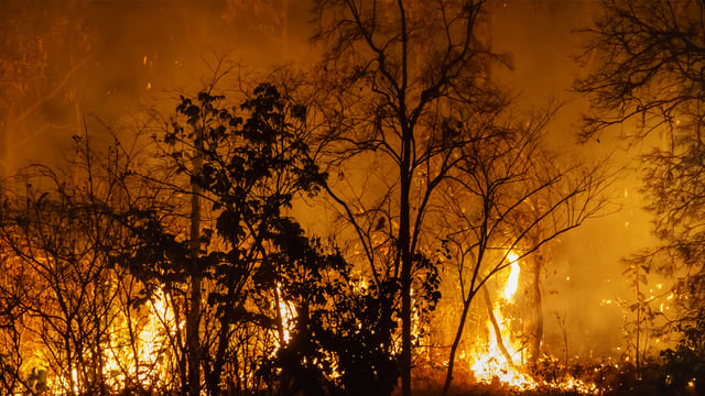
As monsoon season raises ignition risk across Arizona, Maricopa County has deployed nearly 50 AI-assisted wildfire detection cameras mounted on mountain peaks throughout the county, adding a county emergency-management layer to a statewide detection architecture that now spans utilities, state forestry agencies, and local government. The network, built with support from Arizona Public Service, monitors high-elevation terrain from a secure, undisclosed operations facility and routes smoke detections for human review before any fire response is triggered.
Cameras Cover Elevated Terrain with Human Analysts in the Loop
The county network spans elevated locations across Maricopa County, with Thompson Peak serving as the most recent installation. Cameras combine ultra-high-definition imaging, satellite data, and cloud-based software to produce real-time situational awareness and feed alerts to staff at the county’s emergency operations facility, which also monitors flooding and other disaster events. The workflow is explicitly human-supervised at the confirmation stage.
APS Partnership Underpins the County Buildout
Maricopa County developed the network with direct support from Arizona Public Service, the state’s largest electric utility, which had already been operating its own AI camera program in parallel. In March 2025, APS publicly disclosed an AI fire-sensing camera program running 24/7 across high-risk zones, with alerts routed simultaneously to APS fire mitigation teams and local fire dispatch centers.
“The new AI cameras act as powerful extra sets of eyes,” said Scott Bordenkircher, APS Forestry and Fire Mitigation Director, in the company’s March 2025 press release. “When minutes matter, early fire detection provides real-time information so firefighters can respond faster and we can make critical operational decisions about our energy grid to help keep communities safe.”
APS’s internal planning documents call for at least 65 AI cameras operational across its service territory by the end of 2026, scaling up from 31 targeted for end of 2025 and 13 deployed in 2024, according to the utility’s Comprehensive Wildfire Mitigation Plan.
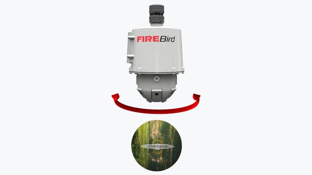
Pano AI Anchors the Utility and State Deployment
The technology underpinning the APS and Tucson Electric Power/UNS Energy programs is supplied by Pano AI, a San Francisco-based startup founded in 2020 that combines 360-degree high-definition cameras, satellite feeds, and trained AI models to identify smoke signatures. The Arizona Corporation Commission confirmed at its April 2026 Wildfire Mitigation Town Hall that Pano AI had no deployed stations in Arizona two years prior, reached 51 active stations by April 2026, and is on track for 88 statewide stations by year-end.
Pano AI’s platform detected 725 wildfires across the United States in 2025 and has been deployed in 17 states, Australia, and Canada, with utility, government, and forestry customers across that footprint, according to the company.
Arizona State Forestry Stands Up AZFIRECAM
One layer up, Governor Katie Hobbs announced the AZFIRECAM initiative on March 27, 2026, giving the Arizona Department of Forestry and Fire Management seven dedicated AI cameras positioned specifically for state dispatch operations. The cameras provide 360-degree live feeds around the clock and are wired directly into the Arizona Dispatch Center, allowing fire management officers to receive automated alerts through the agency’s own infrastructure rather than relying on utility feeds.
The seven AZFIRECAM sites span diverse geography and fire-risk corridors: Sawmill near the Hualapai Mountains, Blake Ranch in Mohave County, Wittmann in western Maricopa County, Dudleyville and Suffering Gulch in Pinal County, Foreman Wash near Tucson, and Chiricahua south of the Dragoon Mountains. The rollout coincided with the near-completion of a new DFFM Dispatch and Incident Command Center in Phoenix.
Diamond Fire Containment Illustrates the Detection Advantage
The operational case for the cameras produced a concrete example in March 2026. An APS-linked camera in Arizona’s Coconino National Forest registered what appeared to be smoke; human analysts confirmed it was not cloud cover or atmospheric dust, alerted state forestry, and crews contained the resulting Diamond Fire to fewer than seven acres. APS meteorologist Cindy Kobold told the Associated Press that the camera system notified the utility roughly 45 minutes faster on average than the first 911 call would have.
The detection speed matters most in lightly populated or remote terrain, where no human observer may be present to spot early smoke. The technology’s value proposition is essentially a compressed window between ignition and initial response in areas that would otherwise go unobserved until a blaze grows large enough to be visible to a passerby.
Per-Camera Cost and Decision Complexity Remain Open Questions
The economic constraint on broader deployment is significant. Pano AI charges approximately $50,000 per camera annually, a price that includes around-the-clock intelligence-center staffing and fire-risk analysis layered on top of the raw hardware, according to AP reporting. At that rate, an 88-station statewide Arizona network would carry an annual operating cost of roughly $4.4 million before any capital or installation expenses, though actual contract terms between Pano AI and its public-sector customers are not disclosed.
The decision-support gap presents a separate challenge. Patrick Roberts, a senior researcher at RAND who recently completed a project on accelerating wildfire management innovation, told AP that early detection does not resolve the downstream command questions an incident commander faces: where to send crews, whether to monitor or immediately suppress, and when to initiate evacuation planning. Those decisions still depend on human judgment and supplementary systems that go beyond what current camera platforms provide.
Arizona’s Approach Reflects a Broader Western Trend
Arizona’s layered structure, spanning utility mitigation programs, a state forestry agency network, and now county emergency operations, mirrors an approach taking hold across the fire-prone western United States. Kurrant previously covered the ALERTWest network, developed by the University of Oregon’s Oregon Hazards Lab, as an example of multi-agency AI camera collaboration in the region. California’s ALERTCalifornia program operates more than 1,240 AI-enabled cameras statewide, while Colorado utilities have begun deploying panoramic AI stations with Pano AI projecting up to 160 sites in that state.
What distinguishes Arizona’s structure is the formal integration of utility infrastructure into county and state operations rather than running parallel systems. APS shares live camera feeds and detection data with local dispatch centers and DFFM, and the Maricopa County network was developed in direct coordination with APS rather than procured independently. Whether that model of utility-anchored, multi-jurisdictional coverage can be replicated in rural counties with smaller emergency management budgets remains the open scaling question as Arizona approaches the height of fire season.