in Barcelona
 3 to 5 Nov 2026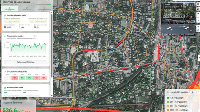
The city of Saint-Cloud, a western suburb of Paris in the Hauts-de-Seine department, has begun using NEXQT Mobilité, a French analytics platform that monitors road traffic continuously across every street in the commune. The tool draws on anonymized GPS data from more than 30 vehicle manufacturers and is funded with a €19,275 grant from the Métropole du Grand Paris under its “Innover dans la Ville” innovation program. Announced at the end of June 2026, the rollout is meant to give municipal services a fuller, regularly refreshed view of local circulation than periodic roadside counts can offer.
Why Roadside Counters Left The City With A Partial Picture
Until now, measuring traffic in Saint-Cloud meant installing temporary counters on a handful of roads, an approach the city characterizes as costly and frozen to a single moment in time. The NEXQT model instead covers the whole road network, with five years of history and monthly updates fed by daily data. That shift moves the city from spot sampling toward continuous, network-wide observation, a distinction that matters when the goal is to judge localized measures whose effects spread onto neighboring streets.
What The Platform Reports, Street By Street
Through maps and simple charts, departments such as the roads service can see vehicle volumes, observed speeds, and the type of traffic on each street, alongside estimated CO2 and pollutant emissions. The figures are derived from anonymized GPS traces covering passenger cars, light vehicles, and heavy goods vehicles. Because emissions are modeled from the same movement data, the city can tie air-quality estimates to measured flows rather than to broad averages.
Traffic Calming, Cycling, And Spillover: The Intended Use Cases
Saint-Cloud lists four main uses. The first is calming residential areas by identifying streets carrying heavy through-traffic and measuring the effect of interventions such as 30 km/h zones, speed bumps, and one-way conversions. The second and third are assessing how cycle lanes and pedestrian areas change surrounding traffic, and tracking where vehicles reroute once a street is calmed. The fourth is prioritization, concentrating spending where the data points to the largest impact.
The spillover use is the analytically notable one. Calming a single street often displaces traffic rather than removing it, and network-wide data lets the city act at neighborhood scale instead of one axis at a time.
NEXQT’s Sensor-Free Method And Its Data-Science Stack
NEXQT, a French company holding the Jeune Entreprise Innovante research label awarded in 2023, builds its offer around decarbonization decision support that avoids fixed ground sensors. Its platform pairs floating-car GPS data with open data, satellite imagery from programs such as Copernicus, and machine-learning techniques including random forests and gradient boosting. The company says it validates its emissions models with the LSCE, a CEA and CNRS climate laboratory, and reports emissions down to street and building level.
A Modest Grant Inside Grand Paris’s Innovation Fund
The €19,275 contribution comes through the Métropole du Grand Paris, which groups Paris with 131 surrounding communes and runs “Innover dans la Ville” to co-fund public-sector innovation. Launched in 2021, the fund had supported 156 projects across 71 local authorities for €5.6 million in grants, according to trade outlet Cadre de Ville. Saint-Cloud’s award sits at the small end of that spread, consistent with a software subscription rather than capital infrastructure.
Where NEXQT Fits In A Competitive Traffic-Data Market
Floating-car data has become a common alternative to physical counters, and NEXQT competes in a field that spans both sensor-based entrants and rival data platforms. In November 2025, NEXQT founder Fouzi Benkhelifa pitched the company at The Smart Deal finals, an investment competition staged at the Smart City Expo World Congress in Barcelona, where selected startups could win up to €50,000 in non-dilutive funding.
What The Deployment Signals For Smaller Cities
For a commune of roughly 7.6 square kilometres, the draw is coverage without street furniture, with no counters to install, maintain, or relocate. The open question, common to any floating-car dataset, is representativeness on low-volume residential streets, where sample sizes thin out. If Saint-Cloud publishes before-and-after readings on calmed streets, the project could become a reference for similarly sized Grand Paris communes weighing the same trade-off.