A Waymo vehicle entering a flooded roadway in San Antonio and being swept into a creek is, on its face, a vehicle safety story. The US National Highway Traffic Safety Administration (NHTSA) treated it as one. The recall paperwork calls it a software defect. And technically, it is.
But the more you look at what actually failed on April 20, and what the interim remedy actually required, the more it becomes clear that this episode is a window into something larger: a structural gap in the geospatial and environmental data infrastructure that autonomous urban mobility depends on, and that no one has fully solved yet.
The Fix That Revealed the Real Problem
When Waymo responded to the San Antonio incident, it did two things. It tightened weather-related operational constraints across the fleet. And it updated the vehicle maps.
That second action matters more than it might seem. An autonomous vehicle’s onboard sensors (lidar, radar, cameras) are designed to perceive the world in real time. If the system had simply failed to detect standing water, a sensor fix would have been the logical remedy. But the fix included the maps. That signals something different: the vehicle’s decision-making was informed not just by what the sensors saw in the moment, but by what the geospatial data layer told it to expect. And the map, in that moment, did not know the road was flooded.
“We have identified an area of improvement regarding untraversable flooded lanes specific to higher-speed roadways,” Waymo stated in its voluntary recall communication to NHTSA. “We are working to implement additional software safeguards and have put mitigations in place, including refining our extreme weather operations during periods of intense rain, limiting access to areas where flash flooding might occur.”
The interim remedy was, in effect, a geofencing and map-update operation. Not a sensor patch.
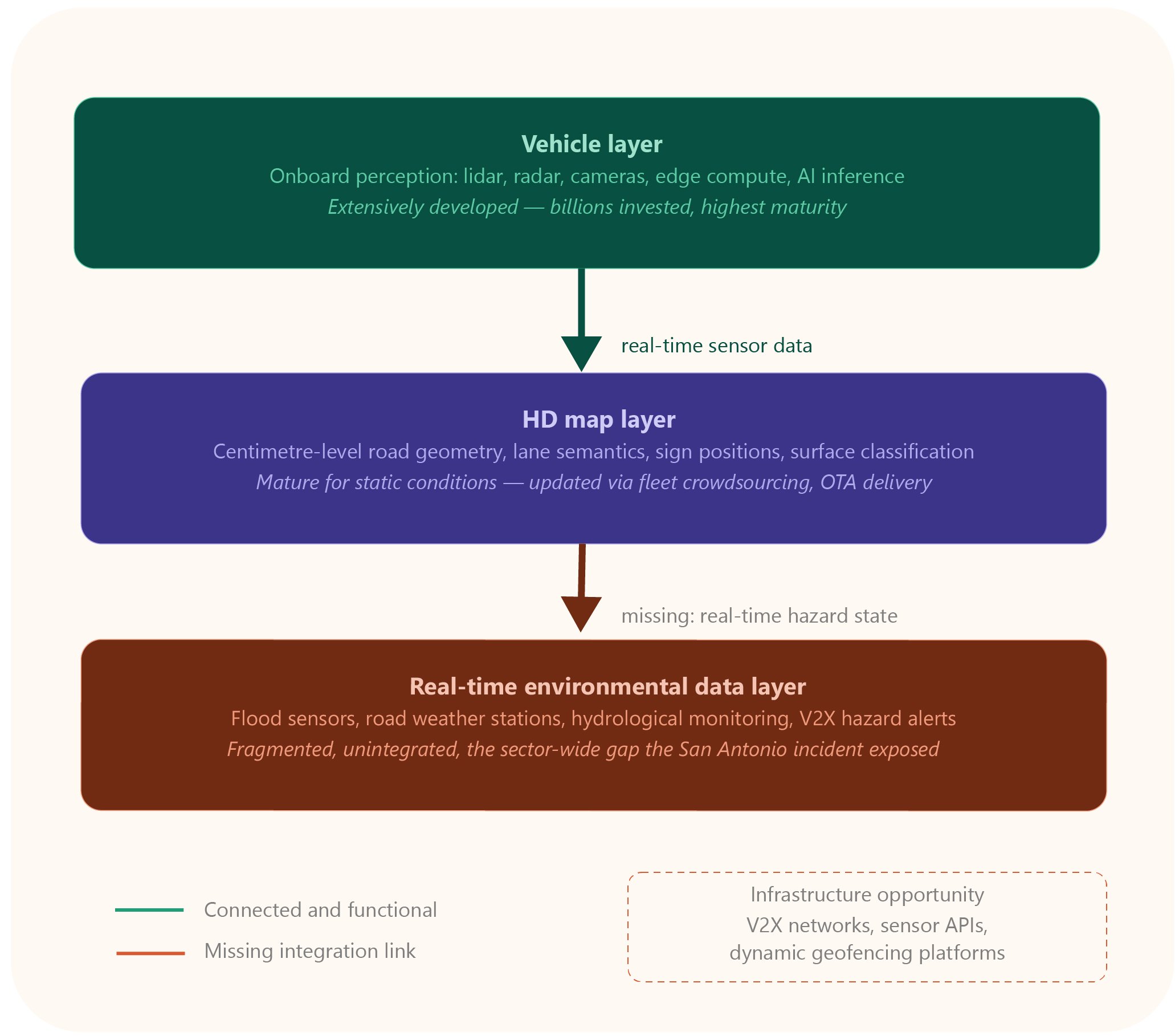
What HD Maps Are, and What They Cannot Yet Do
High-definition mapping is the foundational infrastructure layer of autonomous vehicle operation. Unlike conventional GPS navigation, HD maps encode centimetre-level detail: lane geometry, surface markings, kerb heights, traffic sign positions, and semantic road classifications. Before a Waymo vehicle operates in any new area, the company builds a detailed proprietary map of that territory. The onboard system then uses this map in continuous conjunction with real-time sensor data to localise itself and navigate.
The problem is temporal. HD maps are built from historical data and kept current through crowdsourced updates from fleet vehicles. A road that was dry when the map was last refreshed can become impassable within minutes during a flash flood event. The map layer, however accurate in steady-state conditions, has no mechanism to register that change in real time unless a vehicle in the fleet has already encountered and reported it, or unless an external data source pushes the update.
This is not a Waymo-specific limitation. It is a sector-wide infrastructure gap. The autonomous driving industry has invested enormously in onboard perception: in the quality of lidar point clouds, in the precision of radar returns, in the sophistication of computer vision models trained on millions of hours of driving data. The equivalent investment in the infrastructure that delivers timely, accurate environmental state information to vehicles operating in the field has not kept pace.
Flash flooding is one of the sharpest illustrations of this gap because it is both sudden and locally extreme. A sensor-equipped vehicle approaching a flooded road may perceive ambiguous signals: water surface reflections that distort lidar returns, obscured lane markings, uncertain depth readings. If the HD map has not been updated to flag a flood risk in that corridor, the system has no prior-context anchor to support a conservative decision. The logic runs on stale data.
The Infrastructure Layer That Is Missing
What the San Antonio incident points toward is a need for a new category of data infrastructure: real-time environmental hazard integration into the geospatial layers that autonomous vehicles use for navigation.
This infrastructure does not yet exist at scale. It would require several things working in combination. Flood sensors and water-level monitoring embedded in roadway infrastructure, feeding live status data into mapping platforms. V2X (vehicle-to-infrastructure) communication channels capable of pushing hazard alerts directly to vehicles operating in affected corridors. Dynamic geofencing systems able to automatically exclude flood-prone road segments during high-risk weather windows. And data pipelines connecting meteorological and hydrological monitoring systems to the HD map update workflows of autonomous fleet operators.
Some of these components exist in isolation. Smart city programmes across Europe and North America have deployed road weather sensors, urban flood monitoring systems, and connected traffic management infrastructure. Several cities have live dashboards showing road surface temperatures, moisture levels, and localised weather events. But the integration layer, the bridge between municipal environmental monitoring and autonomous vehicle navigation data, is largely absent.
This is where the gap becomes an opportunity. The cities and regions that build that integration layer first will offer a meaningfully more resilient operating environment for autonomous mobility. Contracts for the sensor networks, the data platforms, and the API infrastructure that connects them represent a significant and underexplored segment of the smart city market.
London as a Test Case
The San Antonio recall lands at a moment when Waymo is preparing its first international commercial deployment. The company has announced plans to launch a fully autonomous ride-hailing service in London, in partnership with the UK Department for Transport, Transport for London, and fleet operations provider Moove, which will handle charging infrastructure and day-to-day fleet management on the ground.
“I’m delighted that Waymo intends to bring their services to London next year, under our proposed piloting scheme,” said Heidi Alexander, UK Secretary of State for Transport, in Waymo’s October 2025 announcement. “Boosting the AV sector will increase accessible transport options alongside bringing jobs, investment, and opportunities to the UK.”
London is a city where this infrastructure gap will be tested acutely. The UK capital receives an average of around 600mm of rainfall per year, spread across a high number of rain days. Its road network is among the most complex in Europe: narrow historic streets, mixed surface conditions, extensive drainage infrastructure of varying age and capacity, and significant localised flood risk in low-lying areas and along river corridors. The HD maps Waymo will need to build for London operations will be starting from a lower baseline of environmental data coverage than the company’s US markets, and will need to be refreshed against a more volatile and less predictable weather environment.
The question of how Waymo, or any autonomous fleet operator, integrates with London’s existing smart city infrastructure, including Transport for London‘s urban traffic management systems and the city’s network of environmental sensors, will be as important to the success of the deployment as the vehicle technology itself.
Over-the-Air as a Model, Not a Solution
One genuinely significant aspect of the recall is what it demonstrated about fleet management infrastructure. Because Waymo owns and operates its entire fleet directly, the interim software and map update was deployed to all 3,791 affected vehicles simultaneously, with no need for vehicles to visit a service centre. NHTSA confirmed that the update had been applied across the fleet by April 20, the same day as the triggering incident.
This over-the-air remediation capability is a meaningful infrastructure achievement. It transforms what would be a slow, fragmented recall process in the conventional automotive world into something closer to a cloud software patch: fast, centralised, verifiable. For municipalities and regulators considering autonomous vehicle deployment frameworks, this model, a fleet operator with full real-time control over every vehicle’s software and map state, offers a different risk profile than consumer AV products, and a stronger basis for incident response.
But OTA delivery is a mechanism, not a source of truth. Its value depends entirely on the quality and timeliness of the data being delivered. The San Antonio vehicle received perfectly functional OTA updates in normal operation. What it lacked was a map that knew the road ahead was underwater.
That is the gap the sector now needs to close, and closing it will require investment not in the vehicles, but in the infrastructure around them.