Harris County is moving forward with a sensor-based roadway flood warning network funded by a $2 million federal grant awarded in 2022, with engineering work now underway and pilot installations targeting the region’s most vulnerable unincorporated roads before the 2026 Atlantic hurricane season.
A Long-Awaited Federal Grant Reaches the Field
The funding originates from the U.S. Department of Transportation‘s Strengthening Mobility and Revolutionizing Transportation (SMART) grants program, which was established under the Bipartisan Infrastructure Law and allocated up to $500 million over five years for projects advancing smart community transportation technologies. Harris County was among the recipients in the program’s fiscal year 2022 cycle.
Progress on the project accelerated in January 2026, when the Harris County Commissioners Court voted unanimously to advance contract negotiations with Houston-based engineering firm J.M. Torres and Associates LLC, which specialises in real-time flood intelligence alert systems and data collection infrastructure.
“The project will install seven emergency flood warning measures across the four precincts,” Harris County Precinct 2 media specialist Alonzo Guadarrama said in an email to Community Impact. “These systems will be able to detect roadway flooding in real time and alert drivers, improving safety and helping reduce the risk of flood-related accidents.”
Sensor Scope and Road Coverage
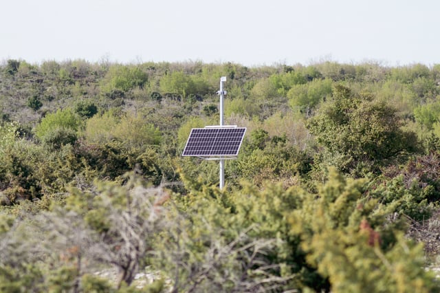
The system’s design is based on a county-wide risk assessment that identified 117 high-risk locations. According to Samuel Pena, Harris County‘s Chief of Infrastructure and Disaster Recovery, the study flagged approximately 60 miles of high-risk flood-prone county roads and a further 60 miles of medium-risk roadways, covering around 290 additional locations.
Sensors will be deployed across both categories, providing real-time water depth data on a model comparable to what the Harris County Flood Control District already operates for rivers and bayous. “The sensors are designed to give real-time data on the condition of those roadways similar to what the flood control district has for the rivers and the bayous, except these are going to be focused on the roadways,” Pena told ABC13 in February 2026.
The rollout is structured in two phases. The initial phase will make water level data available via a public-facing online dashboard, allowing residents and commuters to check road conditions before heading out. A second phase will introduce automated real-time alerts. County officials have not yet announced a full installation timeline or specific road locations, though Pena indicated the first phase should be completed within approximately 18 months of project launch.
The Safety Case Behind the Investment
Harris County’s exposure to flood risk is substantial. Data compiled by nonprofit First Street Foundation estimates that nearly 812,000 properties in the county, representing close to 58% of all properties, face some risk of flooding over the next 30 years. The region’s vulnerability was starkly illustrated during Hurricane Harvey in 2017, which inflicted an estimated $125 billion in damage nationally, with Harris County accounting for a significant share.
The proposed warning system also addresses vehicle-based casualties, which represent a disproportionate share of flood fatalities. According to National Weather Service data cited by county officials, more than 60% of flood-related deaths occur in vehicles, with drivers entering flooded roads rather than being swept away without warning. The county’s “Turn Around, Don’t Drown” messaging has been a consistent public safety effort, but officials say passive signage has limitations that sensor-activated alerts and automated gate closures are designed to overcome.
A Neighbourhood-Level Sensor Model Taking Hold Across the Region
The Harris County project is part of a broader shift in the Greater Houston area toward granular, location-specific flood intelligence, moving beyond county-wide river gauge systems toward road-level situational awareness. In a parallel deployment, the Galveston County Consolidated Drainage District installed seven AI-powered flood sensors in Friendswood and League City in April 2026, with six units covering the Clear Creek watershed and one targeting Dickinson Bayou. That system, developed by Simplicity Integration and powered by Axonis decision intelligence, combines live sensor readings with rainfall totals, stream gauge data, weather station inputs, and soil saturation conditions to generate hyperlocal alerts.
The contrast between the two approaches reflects differing scales and procurement models. Galveston County’s deployment is already live and subscription-based for residents wanting location-specific notifications. Harris County’s system is larger in scope, publicly funded through a federal transportation grant, and targets unincorporated road infrastructure where municipal flood warning coverage has historically been thinner. This type of federal SMART grant mechanism was also the model that enabled New Orleans to move toward a real-time urban flood sensor network, a deployment Kurrant covered in 2024 involving partners United Way, Verizon, and developer Hyfi.
Funding Structure and No-Cost Model for the County
Precinct 2 Commissioner Adrian Garcia confirmed that the $2 million grant carries no local match requirement, meaning the project will be delivered at no direct cost to Harris County taxpayers. The grant was awarded in 2022, and the extended timeline to implementation reflects the county’s process of completing a feasibility study, identifying risk locations, and negotiating engineering services before moving to construction.
The broader post-Harvey federal funding environment for Harris County remains complex. Separately, the Harris County Flood Control District is navigating potential deadline pressures on more than $245 million in HUD-allocated disaster recovery grants tied to the county’s 2018 bond program, with several infrastructure projects at risk of missing a February 2027 state-imposed deadline. That funding stream is distinct from the SMART grant program and involves different federal and state oversight structures.