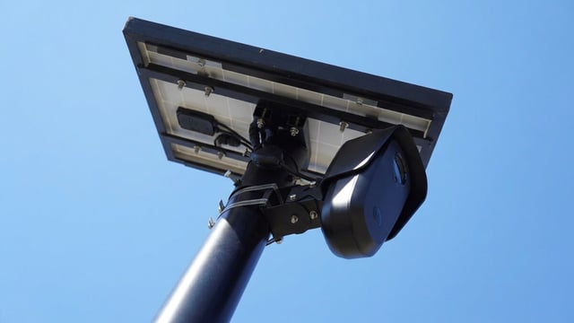
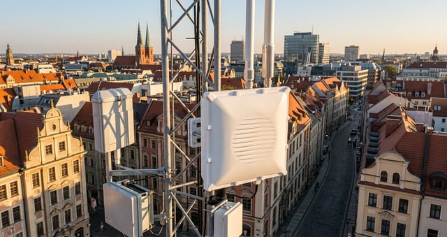
The New York City Department of Transportation announced June 2 that it will scale a machine vision traffic monitoring initiative from 20 pilot locations to approximately 100 intersections across all five boroughs, with around 80 new installations planned for 2026. The sensors, supplied by Vivacity, mount on existing street infrastructure and use artificial intelligence to anonymously track pedestrians, cyclists, buses, and vehicles in real time.
The deployment represents a significant shift in how the city collects traffic data. For decades, manual counts dominated, inspectors with clipboards standing curbside for brief windows, yielding incomplete snapshots of how streets actually function. The new approach operates continuously, capturing changes in travel patterns by time of day, season, and street design.
How The Sensors Capture Movement Patterns
The devices measure speeds, capture turning movements, and map how different users move through intersections. Machine vision technology classifies each mode on the fly, then feeds that raw data through processing algorithms that run directly on the device. The sensors can identify areas where pedestrians are crossing mid-block instead of at crosswalks, helping identify locations where a mid-block crosswalk would be beneficial.
One powerful capability stands out: near-miss detection. The system flags instances where a vehicle nearly collides with a cyclist or fails to yield to a pedestrian. Rather than waiting for crashes to accumulate, the DOT can flag high-risk intersections and prioritize redesigns before serious incidents occur.
Privacy Architecture Built Into The Design
Privacy-by-design is embedded from the start. Video footage is processed in real time and immediately discarded, with only anonymous data retained. Faces and license plates are deliberately obscured in any video footage. The City of New York owns the data, with no personally identifiable information stored in city systems.
This approach sidesteps the surveillance concerns that have plagued similar initiatives elsewhere. The processing happens on the edge device itself, not in cloud infrastructure that might accumulate sensitive information.
Strategic Uses For Traffic Pattern Data
The DOT intends to use the data to evaluate effectiveness of street redesigns, allocate limited curb space more strategically, and identify transit access gaps. The agency expects to build a dataset that measures how pedestrian and cycling volumes change across the city and over time.
“Safer street design starts with understanding what is actually happening on the street,” said NYC DOT Commissioner Mike Flynn in the June 2 press release. “These high-tech sensors will help us evaluate how people are walking, biking, and driving so we can design safer streets and encourage safer behavior.”
Deployment Scale And Implementation
The project cost is approximately $300,000, a relatively modest outlay for citywide coverage. The sensors will be installed along a broad mix of corridors, including busy commercial streets and residential neighborhoods, allowing the agency to collect information from many different types of streets.
Site selection reflects operational strategy: rather than concentrating sensors on major avenues, the DOT prioritized diversity. Residential blocks, commercial corridors, and transit hubs all figure into the rollout, ensuring the resulting dataset captures the complexity of urban mobility rather than skewing toward high-traffic zones.
Vendor And Competitive Landscape
Vivacity supplies the sensors. The company raised $8.5 million in funding to expand its transport data collection into North America, with the broader strategic goal of reducing traffic injuries and deaths through predictive, data-driven planning.
The NYC expansion underscores growing momentum in smart city traffic analytics. Municipal transportation agencies increasingly recognize that reactive decision-making, responding to crash patterns after fatalities mount, fails communities that deserve prevention-first approaches. Data visibility into how streets are actually used, not how planners assume they are used, has become a competitive advantage.
What The Expansion Signals For Smart City Adoption
The scale-up from pilot to citywide deployment signals confidence in both the technology and the operational model. A 2023 pilot that survived three years of real-world testing and weathering is now trusted for 100-location rollout. That progression matters: pilot programs frequently stall, but this one moved into production deployment.
For other cities watching NYC’s moves, the lesson is clear. Traffic sensors that respect privacy while delivering rich behavioral data address a genuine planning gap. The cost structure and operational simplicity suggest scalability beyond New York’s geography.