Pattaya City is deploying an AI-powered intelligent water management system designed to predict, monitor, and communicate flood risks in real time, with a first operational phase expected by July 2026 and a full 100-point sensor network in place by August. The initiative represents a structural shift in how the coastal tourist city handles stormwater and emergency response during the annual monsoon season.
A Persistent Problem Gets a Networked Solution
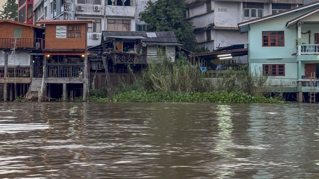
Pattaya’s low-lying geography and rapid urban growth have made seasonal flooding a chronic challenge for decades. The downtown area sits in a natural basin where water from the eastern hillside districts drains rapidly into urban streets during heavy rainfall, overwhelming a drainage infrastructure that has long been underdimensioned for the city’s development pace. A 2018 Thai Cabinet resolution formally tasked the Ministry of Interior with addressing Pattaya’s flooding, drainage, and wastewater management issues across a master plan area covering 226 square kilometres, though large-scale physical infrastructure upgrades have moved slowly.
The new smart water management system does not replace that physical infrastructure pipeline but complements it with a real-time data layer. By instrumenting existing drainage networks and road surfaces, the city aims to gain operational awareness of flood dynamics before they become emergencies.
Sensor Architecture and Monitoring Coverage
The first deployment phase will include approximately 43 underground drainage sensors and 15 road-surface monitoring points. These devices measure water levels, volume, and flow rates inside pipes and at street level, allowing the city to track how stormwater moves from eastern catchment areas toward the urban core in near-real time. Flow meters and cameras supplement the sensor array, providing visual confirmation alongside quantitative measurements.
A second phase, scheduled for completion in August 2026, will extend the network to over 100 monitoring locations across the city. The system is being developed jointly by Pattaya City and the Chonburi Provincial Administrative Organization, with integration of weather forecasting data and river-level monitoring from provincial systems to sharpen predictive accuracy.
Predictive Capability and the Rainfall Threshold
One of the system’s stated technical targets is handling rainfall events of up to 130 mm per hour, a threshold well above the 60-70 mm events that currently take around two hours to drain under existing conditions. By modelling flow direction and velocity across the sensor network, the AI component is intended to forecast how quickly floodwater from the eastern districts will reach vulnerable urban zones, giving emergency teams a lead time they do not currently have.
Officials said the platform will also integrate with railway road construction works near Khao Noi and Khao Talo. Phase 2 of that infrastructure project, expected to complete in 2027, is anticipated to further reduce flood conditions by improving subsurface drainage capacity along one of the city’s most flood-prone corridors.
Public Alerts and Automated Traffic Warnings
The system’s public-facing outputs are designed to reach residents through multiple channels. Digital variable message signs and automated traffic alert displays are planned for several high-risk roads, including sections of Sukhumvit Road in South Pattaya and Pattaya Third Road near the Moom Aroi intersection.
A colour-coded alert protocol will be integrated with the “Pattaya Connect” mobile application and with SMS broadcast systems. Green signals indicate normal drainage conditions; orange alerts call for elevated caution; red notifications signal dangerous flooding and potential road closures. The objective is to eliminate the current dependency on municipal officers physically closing roads during storms, replacing manual observation with data-triggered automated responses.
From Complaint-Driven to Data-Driven Response
City officials framed the operational change in explicitly data-centric terms. Rather than waiting for residents to report flooding through complaints or for field inspectors to arrive on scene, the system will continuously ingest sensor readings to detect anomalies and trigger responses autonomously. Officials indicated the accumulated dataset will also enable longitudinal analysis of flood patterns, rainfall intensity, drainage capacity trends, and traffic disruption impacts, supporting better capital planning for future infrastructure investment.
The approach mirrors a trajectory being pursued by several Asian cities investing in sensor-dense urban water management. Kurrant previously reported on Seoul’s AIoT-based flood inundation monitoring and prediction system in Gangnam District, which similarly combines real-time sensor ingestion with AI relearning to forecast flooding conditions in advance. For broader context on the technologies underpinning these deployments, Kurrant’s original feature The Smart Tech Monitoring, Preventing Flooding examines the sensor architectures and communications infrastructure cities are using to stay ahead of rising waters.
Vendor Identification and Project Budget Remain Undisclosed
No technology vendor or system integrator has been publicly identified in connection with the Pattaya deployment. The total project budget has also not been disclosed in official communications reviewed for this article. The overall flood management programme, of which this smart monitoring layer is a component, is described as a 3-4 year initiative, with the physical drainage infrastructure improvements expected to take longer to complete.